Subzones™
SUBZONES™:
Customize your map based on your team’s needs.
Make it easy for your team to succeed.
Apartment Mapping
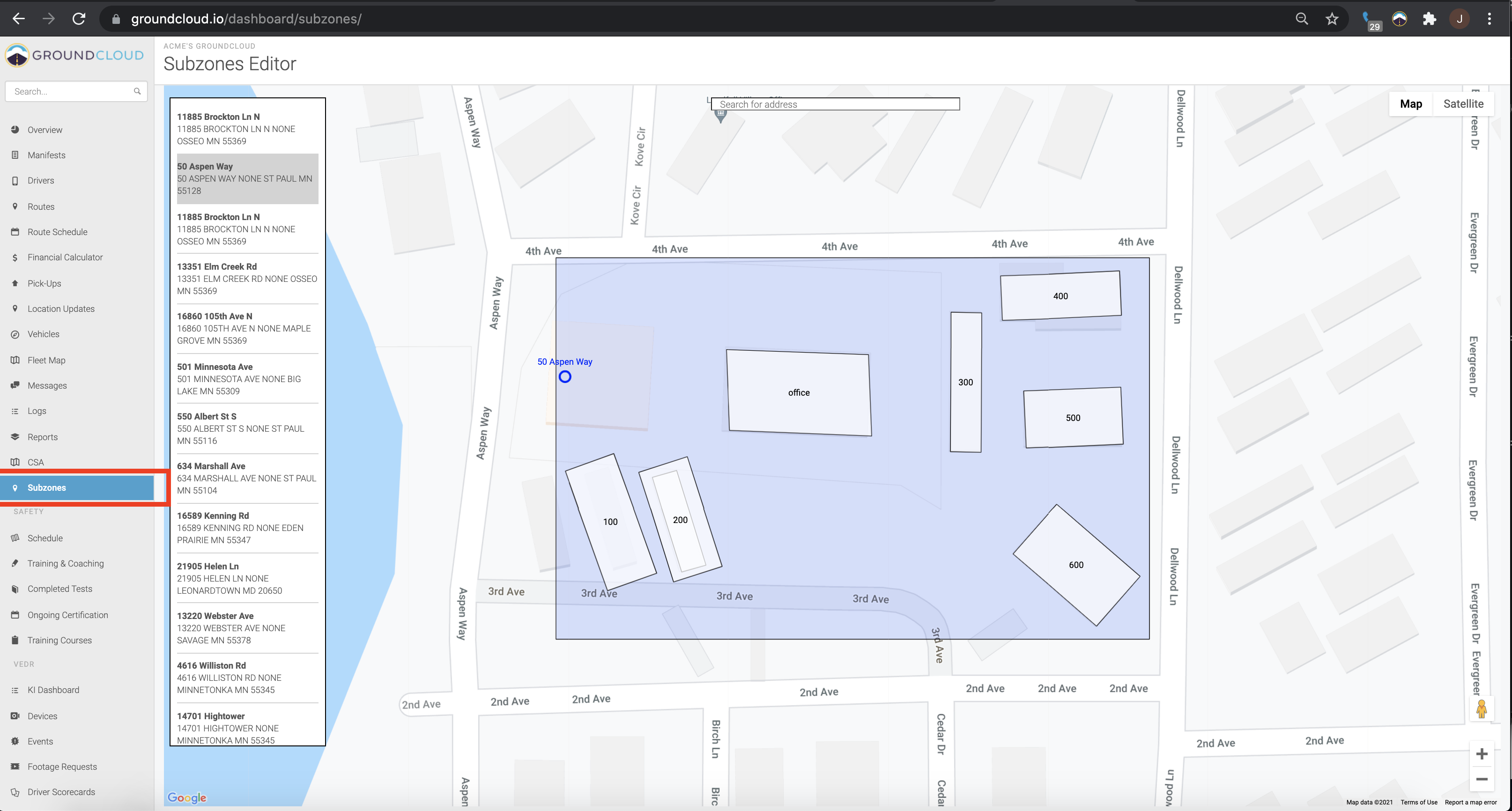
No more time wasted searching for vageuly-labeled buildings that all look the same in any given complex. Label address ranges (100s, 200s, 300s) on your map through the Subzones™ feature so drivers can find the right location in no time, no matter how many cookie-cutter buildings there are.
Hazardous Road Avoidance
No more drivers driving toward areas prone to flooding at certain times of the year, closed roads, or restricted areas. Make “no-go” zones or share other details with your drivers to ensure they stay safe and out of harm’s way.
POI Mapping
GPS doesn’t always take you to the exact building of a multi-building complex, base, or warehouse. Get your driver to the correct door with ease by mapping the sublocations of your stops (front office, apartment mailrooms, docks, front doors, etc.) in greater detail than what GPS provides alone.
Codes and Important Information
Adding gate codes has never been easier than with our Subzones™ feature. Add useful information tied to addresses on your routes such as which door to deliver the package and gate codes to enter the community to ensure quick, efficient deliveries every time.
We've got you covered.
Both managers and drivers can add to the map using the Subzones™ feature. Add something once and it stays for good. However, if you ever need assistance, our exceptional team is here to support you with your map creation. Just send your maps in to us and we are always here to help!

Appartment & POI Mapping
Apartment Mapping
- Easily label the map with address ranges for easy location.
- Save your drivers time and save yourself money by increasing efficiency through apartment mapping.
- Ensure better accuracy of deliveries, since it’s easy to mistake one apartment or building for another when they all look alike.
POI Mapping
- Label points of interest (POIs) to easily find where exactly your packages are supposed to be delivered.
- Drivers can save themselves the trouble of searching for the front door, the main office building, the leasing office, and more.
- No more struggling to find the correct dropoff spot because the GPS picked a random spot in the multi-building area. Clearly see the buildings you frequent on your map.
Communicate Critical Information
Dangerous “NO GO” Zones
- Knowing where to go on the map is important, and so is knowing where NOT to go.
- Label dangerous zones that are off limits to drivers to ensure their safety and reduce the risk of potentially fatal accidents.
- You can label construction zones, restricted areas, areas prone to flooding, and more. It’s entirely up to you – our Subzones™ feature is highly customizable, including the use of emojis.
Access codes
- Input important information such as gate codes and combinations right on the map.
- Drivers can be more efficient when they don’t have to search for someone to let them in or track down the recipient to let them in via phone call.

100% SUPPORT IN
MAP CREATION
We’ve got you covered
- If you need support or assistance with creating your map and customizing it to your team’s needs, our stellar support team is here to help.
- Send your maps to us, and we can help you with the rest.
Other Features
- Satellite and Map views available
- See the mapped areas and deliveries associated with them in the MyDrive feature once you’ve entered your subzones.
How do I make a Subzone™? | FAQ
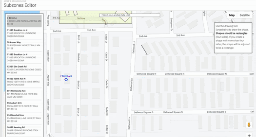
How do I create a Subzone™?
There are 4 methods for subzone entry.
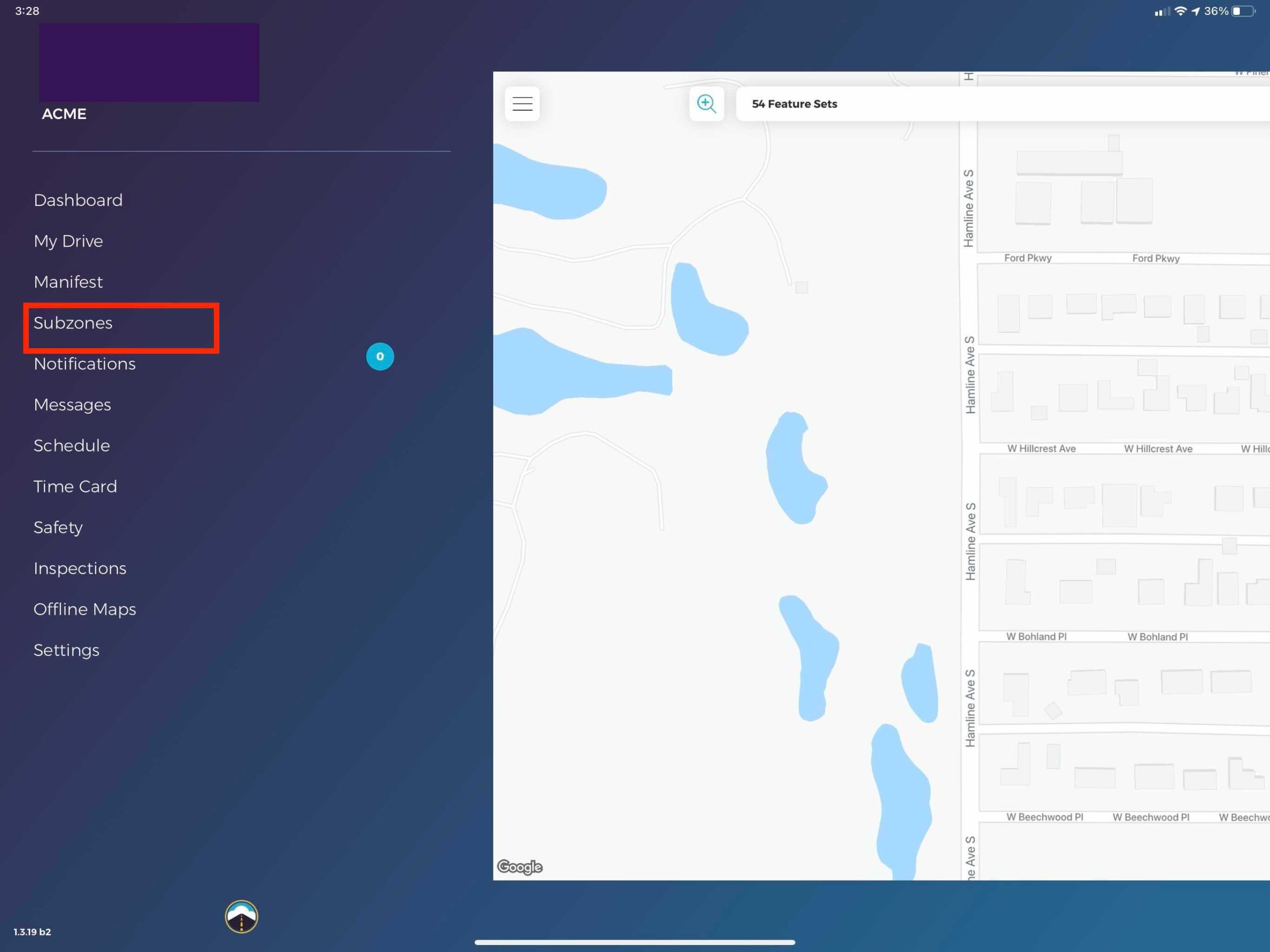
- Log in to any driver account using an iOS device and the GroundCloud app and select the subzone tab.
- Log on to your management portal and click on the Subzone™ tab, located on the left navigation menu.
- Send in a map of the apartments to our amazing support staff with some information to have us map it for you.
- Search for the address you want to add zones to and then start drawing!
How are my Subzones™ displayed to drivers?
- Subzones™ will be displayed as part of the MyDrive map for drivers as they approach a pickup or delivery. Think of it as a map layer.
Are my Subzones™ available across all drivers?
- Of course! Put your drivers to work mapping your routes and make every other driver more efficient when they make the next delivery.